


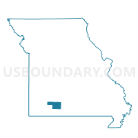
GARRISON Voting District, Christian County, Missouri
About
Outline

Summary
| Unique Area Identifier | 607479 |
| Name | GARRISON Voting District |
| County | Christian County |
| State | Missouri |
| Area (square miles) | 34.90 |
| Land Area (square miles) | 34.89 |
| Water Area (square miles) | 0.01 |
| % of Land Area | 99.96 |
| % of Water Area | 0.04 |
| Latitude of the Internal Point | 36.85295190 |
| Longtitude of the Internal Point | -93.01506930 |
Maps


Graphs
Select a template below for downloading or customizing gragh for GARRISON Voting District, Christian County, Missouri


Neighbors
Neighoring Voting District (by Name) Neighboring Voting District on the Map
- BRADLEYVILLE Voting District, Taney County, MO
- CHADWICK Voting District, Christian County, MO
- LEAD HILL Voting District, Christian County, MO
- SENECA Voting District, Christian County, MO
- SOUTH LINN Voting District, Christian County, MO
- TANEYVILLE Voting District, Taney County, MO
Top 10 Neighboring County Subdivision (by Population) Neighboring County Subdivision on the Map
- Swan township, Taney County, MO (10,011)
- Beaver township, Taney County, MO (890)
- Chadwick township, Christian County, MO (409)
- South Linn township, Christian County, MO (238)
- Garrison township, Christian County, MO (197)
- Lead Hill township, Christian County, MO (148)
- Seneca township, Christian County, MO (112)